No Products in the Cart
Call Us: +1 866 300 9012
contact@measur.ca
|
AGL Altitude |
System Precision |
System Accuracy |
Weight With Battery |
100 m |
2.5 cm |
3 cm |
1.1 kg |
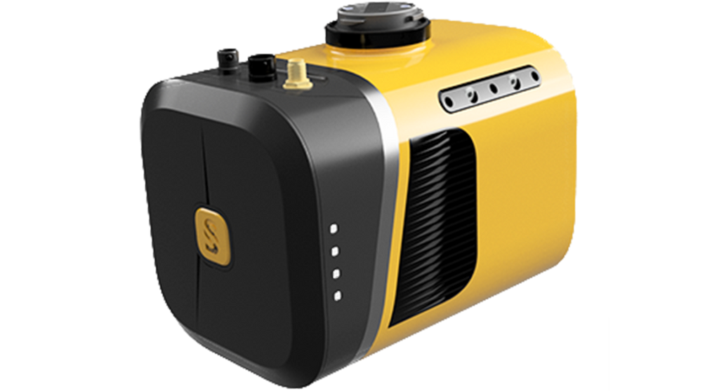
YellowScan Mapper+ UAV LiDAR system integrates the Livox AVIA laser scanner with a high-performance GNSS-aided INS. This lightweight, standalone, and easy-to-use lidar system gives accurate and stable results over a wide range of applications.

Why Mapper+?The Mapper features an Applanix INS giving it a fast, stable, and high-accuracy result. It follows the entire Applanix processing workflow to get cm-level results. CloudStaion processing software includes terrain module, strip adjustment, and the color module for creating high-resolution point-clouds.
|
|
 |
 |
Colorize your point cloud using the Camera Module extensionYou can now use our very own camera module on the YellowScan Mapper+. Operating the camera will be as simple as what philosophy indicates: “Just press the Yellow button”. The camera is powered through the Mapper+ and its data is stored on a dedicated SD card. |
Carry your YellowScan Mapper+ on a dedicated backpackIn this hardshell backpack with custom precut foam, you can easily carry your LiDAR with everything you need (LiDAR system, software, batteries, laptop, data storage). This backpack is the size of a carry-on luggage which fits in any airline overhead compartment. |

Connect your Mapper LiDAR system to your DJI SkyportThe YellowScan Mapper+ can be used with the DJI Skyport. The Mapper+ is compatible with the DJI M300…but not only. We have a bunch of customers flying their UAV with our product: multirotor, fixed-wing and helicopter drones.
|
|
Connect your YellowScan Mapper+ LiDAR system with Gremsy PortThe YellowScan Mapper+ is also compatible with the Gremsy port for quick release and easy integration on a wide range of UAVs.
|
|
| Precision (1) | 2.5cm |
| Accuracy (2) | 3.0cm |
| Echoes per shot | Up to 3 |
| Laser wavelenght | 905nm |
| GNSS-Inertial solution | Applanix APX-15UAV |
| Scanner field of view | 70.4° |
| Shots per second | Up to 240k |
| Weight batt. incl. | 1.3kg (2.9lbs) |
| Weight batt. excl. | 1.1kg (2.5lbs) |
| Size | L15cm x W10.4cm x H12.3cm |
| Autonomy | 1 hours typ. |
| Power consumption | 19W |
| Operating temperature | -20 to +40°C |
(1) Precision, also called reproducibility or repeatability, accounts for the variation in successive measurements taken on the same target. Here precision value is obtained by averaging the precision from 3 flight levels @60, 90 and 120mAGL. At each flight level, the precision is considered as the mean value of absolute elevation differences between 2 flight lines recorded in opposite directions over a nadir-located 40m² hard surface area.
(2) Accuracy is the degree of conformity of a measured position to its actual (true) value. Here accuracy value is obtained by averaging the accuracy from 3 flight levels @ 60, 90 and 120mAGL. At each flight level, the accuracy is considered as the RMSE value of the elevation differences between targets and the point cloud extracted from 2 flight lines recorded in opposite directions. Validation targets are located within a 40m wide corridor centered along the flight line axis.