No Products in the Cart
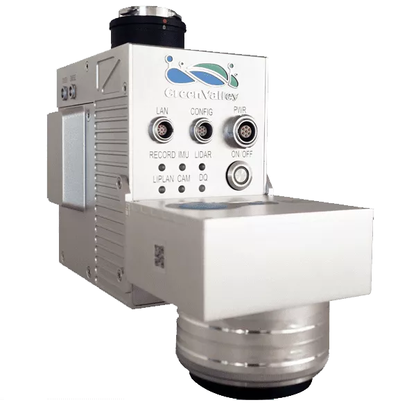
The LiAir V70 is a lightweight UAV or sUAS-mounted LiDAR mapping system.
This lightweight 3D surveying and mapping payload was designed for DJI’s Matrice 600 Pro & DJI M300 RTK & DJI’s Matrice 210 series platforms. LiAir V70 provides highly accurate 3D point cloud data and is a great fit for applications in a wide variety of industries, including forestry and land mapping. It also provides the option to be equipped with a high-definition digital camera to generate photogrammetry products as well as true colour 3D point clouds.
|
Range Accuracy ±2 cm
|
Weight
1.1 kg(Incl.Camera)
|
|
Laser Sensor: Livox AVIA
Range Accuracy: ±2 cm
Detection Range (@100klx): 190 m @ 10% reflectance, 450 m @ 80% reflectance
System Accuracy: ± 5 cm
POS System Performance: Attitude: 0.008° (1σ) Azimuth: 0.038° (1σ)
Onboard Storage: 128 GB
Working Temperature: -20 ℃ - 40℃
Mounting Platform: DJI’s Matrice 600 Pro, M300 RTK & M210
Camera (Optional): Sony A5100
Weight: 0.9 kg (Excl. Camera) 1.1 kg (Incl. Camera)
Dimensions (Incl. Camera): 178 x 81.6 x 140.2 mm
Acquisition/PP POS Software: LiAcquire Web & LiGeoreference
Field of View: 70.4° (Horizontal) x 4.5° (Vertical)
Scan Rate: 240,000 pts/s
MAX Points Per Second: 720,000 points/s (triple return)