[Webinar] ScoutDI: Revolutionizing Confined Space UTM Inspections. Register Now

Call Us: +1 866 300 9012

contact@measur.ca

Call Us: +1 866 300 9012

contact@measur.ca
SHOPPING CART

No Products in the Cart

TOTAL:
$0.00

DJI TERRA

The one-stop software for 2D orthophotos and 3D model reconstruction, 2D multispectral reconstruction, LiDAR point cloud processing, and detailed inspection missions.

Transform your data into digital assets

Auto-generate 3D Models with Centimeter-Level Accuracy

Reconstruct images regardless of the scenario, from surveying and mapping, accident sites, power grid equipment, to progress-management for construction projects.
Available in three resolutions, high, medium and low:
SCALE: 400 photos/1GB (single computer) 6,000 photos/1GB (cluster processing)
EFFICIENCY: 30,000 photos/3 days (single computer), 30,000 photos/21 hours (cluster processing)
ACCURACY: Centimeter-level accuracy

LiDAR

In just one click, calculate POS data, fuse point cloud and visible light data, export point clouds in standardized formats, and generate fieldwork reports.


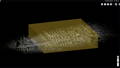
Process point cloud data captured by the Zenmuse L1 in DJI Terra

Multispectral

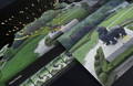
Improve crop yields and drive down costs generating radiometrically calibrated reflectance maps for remote sensing research and more, or produce vegetation index maps including NDVI and NDRE.

Multispectral data captured by the Mavic 3 Multispectral in DJI Terra

Mission Planning

  • Waypoints Mission Planning

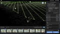
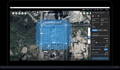
    Create intricate flight routes by employing pre-defined waypoints with customizable settings such as altitude, velocity, gimbal pitch angle, aircraft direction, and a host of other parameters. When tackling intricate and precision-demanding missions, use the 3D Flight Visualization to plan and simulate tasks on existing 3D models.


  • Area Mission Planning

    With just a few simple taps on the touchscreen, you can automate complex missions, streamlining the process of capturing imagery that can then be processed to generate a diverse range of maps and models. These outputs serve to enhance in-depth analysis and to aid decision-making


  • Oblique Mission Planning

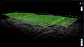
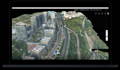
    Oblique mode enables the acquisition of a comprehensive 3D model dataset by tilting the camera at an oblique angle, delivering an exceptionally clear and detailed perspective of the asset


  • Corridor Mission Planning

    Create automated flight missions around roads and railways by simply drawing a line on the map. Adjust mission settings to change the total area mapped, giving you the flexibility to choose between creating high-definition 2D maps and 3D models or quick overviews.


Real-time 3D Mapping


Real-time 3D Mapping:
Quickly render and visualize a 3D model of the mapped area. Make timely decisions based on the preliminary model and check for completeness immediately or plan 3D flights on-site.
Real-time Mapping:
Generate a 2D orthomosaic of the selected area in real-time. Not only is this ideal for creating detailed flight paths in remote areas but it’s also ideal for time-sensitive missions that require quick decision-making on site.
Detailed Inspection Mission Planning:
Create waypoints and flight routes based on one or more points selected in a local 3D model or point cloud (or a third-party point cloud). A simulated camera view including the selected point is displayed onscreen to enable better waypoint selection and more efficient flight route planning, automating inspection workflows.

Efficient Workflows, Accurate Results

Step 1
Step 2
Step 3
POS
GCPs
ROI
Annotation and Measurement
Annotation
Photo Inspection

CONTACT US

Want to get in touch with us? Just fill out the form below and we'll get back to you ASAP.

BACK TO TOP