Call Us: +1 866 300 9012

contact@measur.ca
SHOPPING CART

No Products in the Cart

TOTAL:
$0.00

Multispectral Drones Explained: How They Work and Why They Matter

What is a Multispectral Drone?

A multispectral drone is an unmanned aerial vehicle (UAV) equipped with multispectral sensors that capture data across different spectral bands, including visible and non-visible light. These sensors can measure reflectance in specific wavelengths, typically spanning the visible (RGB) and near-infrared (NIR) regions of the electromagnetic spectrum.

The data captured by multispectral sensors is used to create maps and models that highlight differences in vegetation health, soil composition, and other environmental factors. Unlike traditional cameras, which capture images in the red, green, and blue (RGB) channels, multispectral sensors capture additional bands like red-edge and near-infrared, providing a deeper understanding of the subject matter.

How Multispectral Drones Work

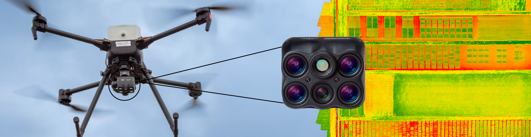
Multispectral drones operate by flying over a designated area and capturing images in different spectral bands simultaneously. These images are then processed using specialized software to produce detailed maps and indices, such as the Normalized Difference Vegetation Index (NDVI), which are used to assess plant health, detect stress, and monitor crop growth.

Sensor Calibration: Before each flight, the multispectral sensors may need to be calibrated to ensure accuracy in data collection. This step is crucial as it accounts for environmental factors like light conditions.

Data Capture: As the drone flies over the target area, it captures images in different spectral bands. These images are georeferenced, meaning they are tagged with precise location data.

Data Processing: After the flight, the captured data is processed using photogrammetry or remote sensing software. This step involves stitching the images together to create a comprehensive map and calculating various vegetation indices.

Analysis: The processed data is then analyzed to extract insights relevant to the application, such as detecting areas of crop stress, assessing soil health, or identifying water bodies.

Applications of Multispectral Drones

Multispectral drones are used in a variety of industries, with some of the most prominent applications in:

1. Precision Agriculture

In agriculture, multispectral drones are invaluable for monitoring crop health, optimizing irrigation, and managing pests. By analyzing data in the red-edge and NIR bands, farmers can identify stressed plants, estimate yield, and implement targeted interventions. This precision farming approach reduces waste, increases efficiency, and maximizes crop yield.

2. Forestry Management

Foresters use multispectral drones to assess forest health, monitor deforestation, and track tree growth. These drones can detect early signs of disease or pest infestation, allowing for timely action to protect valuable forest resources. Additionally, multispectral data aids in the planning of reforestation projects by identifying suitable areas for planting.

3. Environmental Monitoring

Environmental scientists utilize multispectral drones to monitor ecosystems, track changes in land use, and assess the impact of climate change. These drones can detect subtle changes in vegetation cover, soil moisture, and water quality, providing critical data for environmental conservation efforts.

4. Land Management and Urban Planning

In urban planning, multispectral drones help in mapping land use, assessing vegetation cover, and monitoring urban sprawl. They are also used in land management to evaluate soil health, detect erosion, and plan sustainable land use practices.

Key Features to Consider When Choosing a Multispectral Drone

When selecting a multispectral drone, several factors should be taken into account:

1. Sensor Quality

The quality of the multispectral sensors is paramount. Look for drones equipped with high-resolution sensors that capture data in multiple bands, including RGB, red-edge, and NIR. Some advanced sensors also offer thermal imaging capabilities, adding another layer of data for analysis.

2. Flight Time

Longer flight times allow for more extensive data collection in a single mission. Consider drones with extended battery life and efficient power management systems to cover larger areas without the need for frequent battery changes.

3. Data Processing Software

The ability to process and analyze data effectively is crucial. Ensure the drone is compatible with robust photogrammetry or remote sensing software that can handle multispectral data. Some drones come with integrated software solutions that streamline the data processing workflow.

4. GPS and RTK Capabilities

Accurate georeferencing is essential for precise mapping. Drones equipped with Real-Time Kinematic (RTK) GPS offer centimeter-level accuracy, ensuring that your multispectral data is correctly aligned with real-world coordinates.

5. Ease of Use

User-friendly drones with intuitive controls and automated flight planning features can save time and reduce the learning curve. Look for drones that offer easy integration with existing workflows and provide comprehensive training and support.

Top Multispectral Drones on the Market

Multispectral drones have revolutionized precision agriculture, environmental monitoring, and research by offering advanced imaging capabilities. Here, we highlight three of the top multispectral drones available, each equipped with cutting-edge sensors for superior data collection and analysis.

1. DJI Matrice 350 RTK with Sentera 6X Thermal Pro Sensor

The DJI Matrice 350 RTK is a next-generation commercial drone platform designed for high-performance missions. It can be equipped with the Sentera 6X Thermal Pro Sensor, making it a powerful tool for capturing synchronized multispectral, RGB, and advanced thermal data in a single flight.

• Flight Performance: The M350 RTK offers up to 55 minutes of flight time, IP55 protection, and a 7,000-meter maximum flight altitude, allowing it to operate in harsh environments and challenging conditions.

• Transmission System: With the O3 Enterprise Transmission system, it provides triple-channel 1080p HD live feeds and up to 20 km of transmission distance, ensuring stable and interference-resistant communication.

• Sentera 6X Thermal Pro Sensor: This sensor delivers high-resolution data across multiple bands with a 20MP RGB imager and a FLIR Boson 640 radiometric thermal imager. It’s designed for applications like plant disease monitoring, infrastructure inspections, and environmental surveys.

2. DJI Mavic 3 Multispectral

The DJI Mavic 3 Multispectral is a compact yet powerful drone, specifically designed for precision agriculture and environmental monitoring. It integrates a multispectral imaging system that captures data across multiple spectral bands to provide comprehensive insights into crop health and land conditions.

• Compact Design: Despite its small size, the Mavic 3 Multispectral offers excellent performance with easy portability, making it ideal for quick deployments in various field conditions.

• Advanced Imaging: Equipped with multiple sensors, it captures detailed multispectral data that can be analyzed to monitor crop health, detect plant diseases, and optimize resource use.

• Ease of Use: The Mavic 3 Multispectral is user-friendly, featuring automated flight modes and seamless integration with DJI’s ecosystem, making it an excellent choice for professionals seeking a reliable and efficient multispectral drone.

3. Quantum Systems Trinity Pro with MicaSense Altum-PT

The Trinity Pro from Quantum Systems, combined with the MicaSense Altum-PT sensor, is a fixed-wing drone known for its long endurance and large coverage area, making it perfect for large-scale agricultural and environmental surveys.

• Fixed-Wing Efficiency: The Trinity Pro offers extended flight times and can cover vast areas in a single flight, making it ideal for large-scale mapping and surveying tasks.

• Altum-PT Sensor: This advanced sensor captures synchronized multispectral, thermal, and high-resolution RGB data, providing detailed insights for applications like crop management, vegetation analysis, and environmental research.

• Precision and Accuracy: The combination of Trinity Pro’s stability and Altum-PT’s sensor capabilities ensures high-quality data collection, even in challenging conditions.
Sale Off
Trinity Pro

RELATED POSTS

How to Select the Best Drone-Based Ground Penetrating Radar
Ground Penetrating Radar (GPR) technology has transformed how we explore and understand what's beneath the surface, making it an essential...
What Makes the YellowScan Voyager a Unique Drone-Based LiDAR System
The YellowScan Voyager is not just another LiDAR system; it's a cutting-edge solution that stands out in the industry for...
Best Commercial Drones of 2024
The commercial drone industry is evolving rapidly, with 2024 showcasing some of the most advanced and versatile models yet. From...

Get in touch

Give us a call or drop by anytime, we will answer all enquiries within 24 hours on business days. We will be happy to answer your questions.

Contact Information

We would love to hear from you! Our team is always here to help.

  • +1 866 300 9012

  • contact@measur.ca

  • Vancouver, British Columbia

    Calgary, Alberta

    Mississauga, Ontario

    Montreal, Quebec

Name*:

Phone*:

Email*:

Message:

BACK TO TOP