[Webinar] ScoutDI: Revolutionizing Confined Space UTM Inspections. Register Now

Call Us: +1 866 300 9012

contact@measur.ca

Call Us: +1 866 300 9012

contact@measur.ca
SHOPPING CART

No Products in the Cart
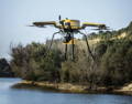
TOTAL:
$0.00

Environmental Monitoring and Conservation

Vital ecosystems, from dense forests to remote mountain ranges, are often inaccessible to researchers, environmental engineers and conservationists due to rugged terrain or hazardous conditions, inhibiting our ability to gather critical data and implement conservation measures effectively. Moreover, traditional methods of data collection, such as ground surveys or manned aerial missions, require substantial time, manpower, and financial resources, resulting in sparse and sporadic monitoring efforts, leaving gaps in our understanding of ecosystem dynamics and conservation needs. 

The Benefit of Drones for Environmental Monitoring and Conservation

Drones have revolutionized the field of environmental monitoring and conservation, offering data-gathering capabilities that were previously unimaginable. Their ability to access remote areas, collect high-quality data, and aid in the development of sustainable conservation strategies is transforming the way we understand and preserve our natural world.

Key Technological Considerations

When considering a drone for environmental monitoring and conservation, there are several key technological aspects to take into account

Payload Capacity and Sensors

Ensure the drone can carry the necessary sensors for data collection such as high-resolution cameras, multispectral sensors, LiDAR, thermal imaging cameras, etc.


Flight Time and Range


Consider drones with appropriate flight times and extended range capabilities to cover areas efficiently.

Look for reliable communication systems for long-range control and data transmission.


Navigation and Data Processing

Drones with autonomous flight features like obstacle avoidance help collect data efficiently and safely. Other features, such as integrated data processing capabilities, offer real-time analysis in the field and can reduce the need for duplicate flights. 

Data Management


Consider drones that offer compatibility with Geographic Information System (GIS) software and other data analysis tools commonly used in environmental monitoring and conservation.


Discover

the Measur Advantage

Find the perfect solution for your needs.

Reduce Expenses

Drones reduce expenses by reducing the need for pricey manned flights and ground surveys, thereby minimizing the high costs associated with human overhead.

Increase Efficiency

Drones increase efficiency by covering large areas, providing high-resolution data from various angles, and enabling remote access to otherwise inaccessible locations.

UAV LiDAR

Mounted on drones, UAV LiDAR provides efficient and precise ground modelling through dense vegetation, enabling cost-effective environmental assessments and evidence-based decision-making for effective conservation strategies.

Enhanced Data Accuracy and Collection

Drones enhance data accuracy and collection in environmental monitoring through their ability to capture high-resolution imagery and sensor data from precise vantage points, reducing errors and inconsistencies compared to traditional methods. 

The Apache 4 Unmanned Surface Vehicle (USV) revolutionizes environmental monitoring, particularly in hydrological studies, by seamlessly integrating with ADCP models like the M9, RTDP, 1200, RiverPro, and RiverRay, ensures flexibility and precision in data collection. Equipped with a single beam echo sounder, the Apache 4 offers accurate depth measurements, enhancing hydrographic surveying. 


With over 2 hours of battery endurance and autonomous operation, it covers vast areas efficiently and safely, reducing risks associated with fieldwork. Integration with positioning and navigation systems further enhances data accuracy and reliability. The Apache 4 prioritizes ease of use and safety, making it an indispensable tool for hydrologists and environmental scientists conducting water flow velocity and discharge measurements in various aquatic environments.

Key Features

Battery Endurance: 2 x 3 hours @ 2 m/s (running on 2 battery sets, support hot-swap). Ensures prolonged operational time, crucial for covering extensive areas or conducting extended surveys without interruption. The hot-swap capability adds to its reliability by allowing continuous operation during battery replacement.


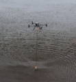
• ADCP Compatibility: Compatible with M9, RiverPro, RiverRay, RioGrande, RCP, and other navigable ADCP. Enables seamless integration with various ADCP systems, facilitating comprehensive hydrological surveys and precise water flow measurements. Compatibility with multiple ADCP models enhances flexibility and ensures the use of the most suitable equipment for specific research requirements.


• Hull Dimension (L × W × H): 1200 mm x 750 mm x 400 mm. 


• Two-color Light (Display satellite and positioning status): Offers visual indication of satellite connectivity and positioning status, allowing operators to monitor the system's navigation capabilities.


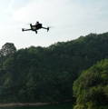
• Anti-wave & Wind Draft: 3rd wind level and 2nd wave level. Ensures stable operation and reliable data collection even in challenging environments. This feature enhances the USV's capability to maintain data quality and consistency, contributing to the success of hydrological surveys and environmental monitoring efforts.

High Accuracy Economy Multibeam for the Apache 4

The HQ-400 Multibeam Sonar System offers integrated functionality for seamless underwater terrain measurement. Equipped with the CMS Multibeam Acquisition Software, this system provides powerful tools for data acquisition and visualization, enhancing efficiency and accuracy in survey tasks such as topographic mapping, capacity calculation for reservoirs, hydrographic surveys, and river profile analysis. With features like ultra-high stability and comprehensive compatibility with various instruments, the HQ-400 system ensures reliable and precise data collection even in challenging underwater environments.

The CHCNAV ACP River Star Series  is available in two models, RS-1200 and RS-600, both featuring a five-beam design with a centralized vertical beam operating at 300kHz, this series ensures precise measurements in diverse water environments. With enhanced hardware and structure design, it guarantees improved efficiency and reliability, crucial for applications such as river flow monitoring, sediment transport studies, hydraulic engineering, and environmental monitoring. Offering reliable data accuracy with a resolution of 1mm/s and a profiling range of 0.15~40m, the River Star Series ADCPs provide professionals in water-related fields with unparalleled performance and reliability. 

The DJI Mavic 3 Multispectral offers centimeter-level RTK positioning that ensures accurate mapping, while its efficient battery life enables extensive coverage, with the ability to cover up to 200 hectares per flight. The drone features obstacle sensing and terrain-following capabilities, ensuring safe and reliable data collection even in challenging environments.


Its intelligent field scouting capabilities facilitate real-time detection of abnormalities in crop growth, aiding in timely management decisions. The Mavic 3 Multispectral is ideal for environmental monitoring and natural resource surveys, such as water enrichment monitoring, forest distribution surveys, and urban green area surveys, further demonstrating its versatility and effectiveness in environmental management.

Key Features

Flight Performance: With a max flight time of 43 minutes, 32 km max flight distance, and omnidirectional obstacle sensing, it offers exceptional flight capabilities.


Camera System: Equipped with a 20MP RGB camera and a 5MP multispectral camera, enabling high-quality imaging and precise data collection for various applications.


Gimbal Stabilization: The 3-axis mechanical gimbal ensures stable and smooth footage, even in challenging conditions, enhancing the quality of aerial imaging.


Sensing System: Utilizes an omnidirectional binocular vision system and infrared sensor for effective obstacle avoidance, ensuring safe and reliable flight operations.


Transmission System: Features DJI O3 Image Transmission Industry Edition, offering high-quality live view up to 1080p/30fps and a max effective signal distance of 15 km, facilitating reliable communication between the drone and the operator.

EchoLogger ECT 400S Echo Sounder

The EchoLogger ECT D052S Echo Sounder, designed by SPH Engineering, serves as a valuable tool across various fields due to its advanced features and reliable performance. Its dual-frequency capability and integrated tilt and temperature sensor make it particularly suited for hydrographic surveying tasks, offering precise measurements of water depths ranging from 1.0 to 200m (50 kHz) and 0.5 to 200m (200 kHz). This functionality enables detailed mapping of underwater terrain, crucial for tasks such as charting water depths and studying aquatic ecosystems.


The echo sounder's compatibility with DJI drones like the M350 RTK enhances its versatility, allowing for seamless integration into drone-based surveying operations. This integration facilitates efficient data collection in challenging or inaccessible areas, contributing to environmental monitoring efforts, resource management, and infrastructure inspection tasks. 

Key Features

Dual-Frequency Capability: The echo sounder operates at two frequencies, 50 kHz and 200 kHz, allowing for versatile measurement capabilities suitable for various underwater mapping tasks.


Integrated Tilt and Temperature Sensor: Equipped with a tilt and temperature sensor, the device provides additional environmental data alongside depth measurements, enhancing the overall understanding of underwater conditions.


Compact and Lightweight Design: Weighing just 460g (echo sounder alone), the device is highly portable and can be easily deployed for fieldwork.


• Wide Measurement Range: The echo sounder offers a measurement range of 1.0 to 200m (50 kHz) and 0.5 to 200m (200 kHz), allowing for detailed mapping of underwater terrain across various depths.


Compatibility with SkyHub and RS232 Interface: the device comes with an RS232 interface and connector for SkyHub, facilitating data communication and synchronization during surveying missions.

Drones for Shallow Water Mapping

The YellowScan Navigator stands out as an ideal solution for shallow water mapping, thanks to its specialized design and advanced features. Specifically optimized for bathymetric survey applications, the Navigator offers high-precision topographic mapping capabilities in shallow water environments such as rivers, lakes, and estuaries. Its wide 44-degree field of view ensures comprehensive coverage, allowing operators to efficiently capture diverse datasets with precision. The integrated camera with global shutter functionality simplifies colourization, enhancing the visual quality of collected data.


The Navigator's versatility extends to its deployment options, as it can be easily mounted on various UAV platforms. It also offers streamlined data processing, ensuring accurate results even in challenging environments. The YellowScan Navigator offers a comprehensive solution for shallow water mapping, combining advanced LiDAR technology, integrated camera capabilities, and robust processing software to deliver efficient and accurate topographic data collection.

Key Features

  • Precision and Accuracy: Offers a precision and accuracy of 3 cm (1.2 inches), ensuring high-quality topographic mapping results.
  • Max. Water Depth: Capable of measuring up to 2 Secchi depths, making it suitable for shallow water mapping applications.
  • Typical Flight Speed: Operates at a typical flight speed of 5 m/s, allowing for efficient data collection.
  • Max. AGL Altitude: Can fly at a maximum altitude of 100 meters above ground level (AGL), providing ample coverage for surveying.
  • Laser Range: Offers a laser range of up to 120 meters, enabling comprehensive data acquisition.
  • Laser Scanner: Utilizes YellowScan's development in laser scanning technology, ensuring reliable performance.
  • GNSS-Inertial Solution: Equipped with the SBG Quanta Micro GNSS-inertial solution for accurate positioning and orientation.
  • Scanner Field-of-View: Features a wide scanner field-of-view of 44°, facilitating broad coverage during scanning.
  • Integrated Camera: Comes with a built-in global shutter camera, enhancing data collection with precise colorization.
  • Autonomy: Provides an autonomy of 45 minutes typical, enabling extended surveying sessions without frequent battery changes.

Drones for High-Accuracy Mapping

The Trinity Pro's PPK and RTK capabilities, combined with high-end GNSS receivers and integrated cameras, enable absolute accuracy down to 1 centimeter, eliminating the need for ground control points. With features like payload damping, easy data access, and a wide range of compatible payloads, the Trinity Pro sets a new standard for high-accuracy survey equipment, making it indispensable for environmental monitoring applications. With a robust Quantum-Skynode autopilot and Linux mission computer, it seamlessly integrates with sophisticated cameras, logging systems, and artificial intelligence tools, facilitating precise data collection with ease and efficiency.


The Trinity Pro offers a leading flight time of up to 90 minutes and extensive area coverage of 700 hectares make it ideal for large-scale environmental surveys. Its vertical take-off and landing capability enables operations in diverse terrains without the need for a runway, enhancing accessibility and safety. Equipped with a downfacing LiDAR scanner and enhanced terrain-following system, the Trinity Pro ensures accurate mapping even in challenging environments.

Key Features

  • Precision and Accuracy: Offers a precision and accuracy of 3 cm (1.2 inches), ensuring high-quality topographic mapping results.
  • Max. Water Depth: Capable of measuring up to 2 Secchi depths, making it suitable for shallow water mapping applications.
  • Typical Flight Speed: Operates at a typical flight speed of 5 m/s, allowing for efficient data collection.
  • Max. AGL Altitude: Can fly at a maximum altitude of 100 meters above ground level (AGL), providing ample coverage for surveying.
  • Laser Range: Offers a laser range of up to 120 meters, enabling comprehensive data acquisition.
  • Laser Scanner: Utilizes YellowScan's development in laser scanning technology, ensuring reliable performance.
  • GNSS-Inertial Solution: Equipped with the SBG Quanta Micro GNSS-inertial solution for accurate positioning and orientation.
  • Scanner Field-of-View: Features a wide scanner field-of-view of 44°, facilitating broad coverage during scanning.
  • Integrated Camera: Comes with a built-in global shutter camera, enhancing data collection with precise colorization.
  • Autonomy: Provides an autonomy of 45 minutes typical, enabling extended surveying sessions without frequent battery changes.

Drone Training


Whether you need one-on-one or group training, our training programs provide the latest practical knowledge while keeping your budget in mind.

Drone Rentals

Looking to rent a drone to meet your evolving drone needs?


You'll find a wide range of industry-leading equipment, from DJI drones to advanced LiDAR systems at Measur. We offer cost-effective and convenient solutions for accessing high-quality drone technology without the commitment of ownership. 

Get in touch

Give us a call or drop by anytime, we will answer all enquiries within 24 hours on business days. We will be happy to answer your questions.

Contact Information

We would love to hear from you! Our team is always here to help.

  • +1 866 300 9012

  • contact@measur.ca

  • Vancouver, British Columbia

    Calgary, Alberta

    Mississauga, Ontario

    Montreal, Quebec

Name*:

Phone*:

Email*:

Message:

CONTACT US

Name:

Company name:

Phone:

Email:

Message:

SPEAK WITH AN EXPERT

Name:

Company name:

Phone:

Email:

Message:

BACK TO TOP