The MagNIMBUS is an advanced airborne magnetometer system revolutionizing detection capabilities with its QuSpin Gen-2 atomic total-field magnetometer sensors. Designed for precision and versatility, this cutting-edge system opens up a realm of possibilities across various applications.
Unlocking New Horizons:
-
UXO and Landmine Detection: Safely locate UXO and landmines concealed within metallic casings, even amidst challenging terrains with vegetation.
-
Tramp Metals and Lost GET Detection: Pinpoint hidden metal objects and ground engagement tools with unmatched accuracy.
-
Infrastructure Mapping: Effortlessly detect buried metal pipes, shielded cables, and abandoned wells for comprehensive environmental surveys.
-
Geological Exploration: Conduct magnetic field surveys for geology and mineral prospecting, identifying regional variations with ease.
-
Archaeological Insights: Uncover buried artifacts and ancient structures with precision, aiding archaeological studies.
Key Features:
-
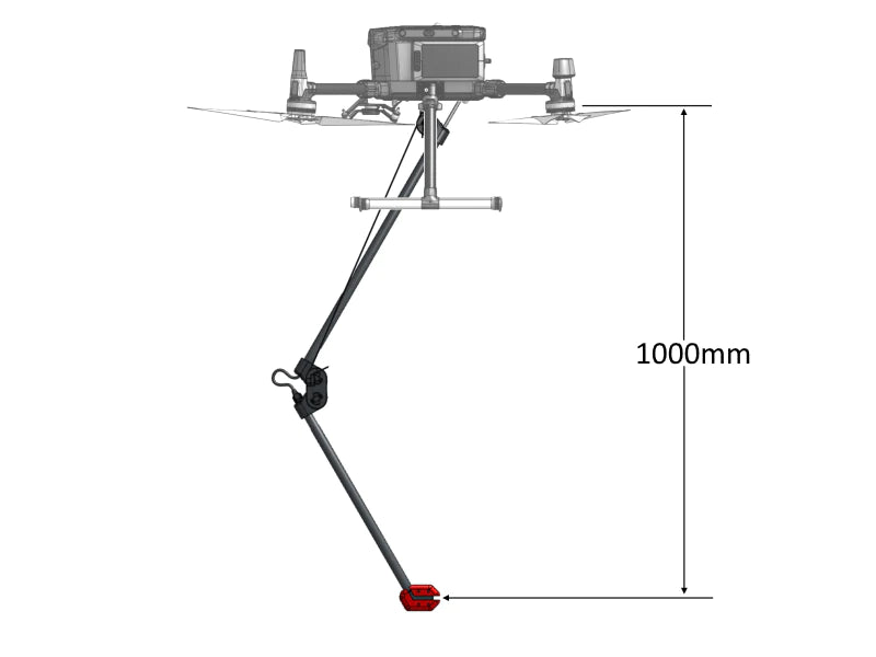
Low Clearance Capability: Fly with confidence at incredibly low heights, safely navigating obstacles and vegetation without risking drone crashes.
-
Self-Foldable Sensor Mount: Simplifies take-off and landing, reducing operator qualifications required for setup, ensuring seamless operation.
System Variants:
-
Vertical Gradiometer: Simplifies data processing, eliminating the need for a magnetic base station.
-
Single Sensor Configuration: Offers comparable detection capabilities, ideal for specialized applications with experienced data processors.
Key Components:
-
Recommended Drone: DJI M350 RTK/M300 RTK, with tailored mountings and cables for seamless integration.
-
QuSpin Gen-2 Sensor: Ensures high-performance data collection, housed in a foldable mount for convenience.
-
SkyHub Onboard Computer: Facilitates data logging and terrain following mode for DJI drones, enhancing operational efficiency.
-
Altimeter: Laser or radar-based, providing accurate altitude measurements for precise flight control.
-
UgCS Expert Software: Enables advanced flight planning and management, optimizing mission success.
-
Geosoft Oasis montaj: Recommended for robust data processing, delivering actionable insights for informed decision-making.
Detection Capabilities:
- Detects items ranging from hand grenades to large UXO, ensuring robust detection even at significant distances.
- While capable of detecting certain types of landmines, it's not recommended for confirming their absence but proves invaluable for Non-Technical and Technical Surveys.
Technical Specifications:
-
HS Code: 90158020 (meteorological, hydrological, geophysical instrument)
-
Compact Design: Folded dimensions of 640x180x75 mm, weighing just 570g for easy transportation.
-
Transportation Case: Compact and durable, ensuring the safety of equipment during transit.
Data examples
Single-sensor configuration, UXO GeoMIL test range
Single-sensor configuration, Balozi test field
Gradiometer configuration, Balozi test field
Discover the future of magnetometer systems with MagNIMBUS, where innovation meets precision, transforming the way you approach airborne magnetic field detection.