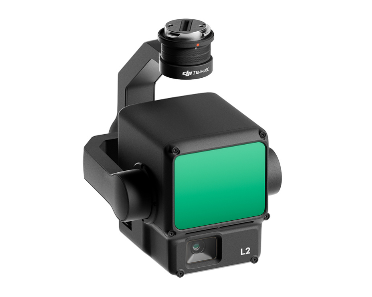
The DJI Zenmuse L2 is an integrated geospatial data acquisition system. It combines frame LiDAR technology, a high-accuracy IMU system, and a 4/3 CMOS RGB mapping camera. This system is designed to provide precise and efficient data collection capabilities when used with DJI flight platforms, particularly when integrated with DJI Terra software. The Zenmuse L2 offers high vertical and horizontal accuracy of 4 cm and 5 cm, respectively, covering a substantial 2.5 km² area in a single flight.
It features exceptional penetration capabilities, smaller laser spots than its predecessor, and supports up to 5 returns. With a frame-based design and improved IMU system, it ensures high-precision mapping, making it suitable for various applications, including land surveying, electricity management, forestry, infrastructure management, and more. Users can easily process point cloud data and achieve accurate geospatial results, enhancing overall operational efficiency.
RGB Camera
Maximum Returns
System Accuracy
Detection Range
20 MP, 4/3 CMOS
5
5 CM Horizontal, 4 CM Vertical (150m AGL)
250m @ 10% Reflectivity
Comprehensive LiDAR Solution
With its robust hardware support, the L2 system excels at conducting precise scans of intricate subjects over extended distances, facilitating faster point cloud acquisition. During operations, users can conveniently preview, playback, and process point cloud models on-site, accompanied by Task Quality Reports generated by DJI Terra. This holistic solution simplifies the process, enhancing overall efficiency and enabling users to achieve high-precision point cloud results with streamlined post-processing.
Elevated Precision Levels
By combining GNSS technology with a highly accurate self-developed IMU, this solution achieves vertical accuracy of 4cm and horizontal accuracy of 5cm.
Exceptional Operational Efficiency
From the moment it's powered on, the L2 system swiftly collects both geospatial and RGB data, covering a wide 2.5km² area in a single flight.
Intuitive User Experience
In conjunction with the Matrice 350 RTK and DJI Terra, the L2 system provides a turnkey solution that is remarkably user-friendly, reducing the operational learning curve.
Expanded Detection Range by 30%
The L2 system offers impressive detection capabilities, ranging from 250 meters at 10% reflectivity and 100 klx, all the way to 450 meters at 50% reflectivity with 0 klx. This extended range also enables a typical operational altitude increase of up to 120 meters, significantly enhancing operational safety and efficiency.
Reduced Laser Spot Size, Enhanced Point Cloud Density
Featuring a smaller spot size of 4×12 cm @100m, which is merely one-fifth the size of its predecessor, the L2 not only detects smaller objects with greater detail but also penetrates denser vegetation, resulting in more accurate digital elevation models (DEM).
Support 5 Returns
In densely vegetated environments, the L2 can effectively capture more ground points concealed beneath foliage
Point Cloud Rate: 240,000 pts/s
Operating in both single and multiple return modes, the L2 can achieve a maximum point cloud emission rate of 240,000 points per second, allowing for the acquisition of a more extensive point cloud dataset in a given timeframe.
Two Versatile Scanning Modes
The L2 system provides support for two scanning modes, catering to users' specific task requirements. In repetitive scanning mode, L2's LiDAR technology delivers uniform and precise point clouds, meeting the demands of high-precision mapping. In non-repetitive scanning mode, it offers enhanced penetration for capturing structural information, making it well-suited for applications such as power line inspection, forestry surveying, and other similar scenarios.
Innovative Frame-Based Design
The frame-based design results in an effective point cloud data rate of up to 100%, further complemented by a three-axis gimbal, opening up new possibilities for various surveying scenarios.
Typical data. Measured using a flat subject with a size larger than the laser beam diameter, perpendicular angle of incidence, and an atmospheric visibility of 23 km.In low-light environments, the laser beams can achieve the optimal detection range. If a laser beam hits more than one subject, the total laser transmitter power is split, and the achievable range is reduced. The maximum detection range is 500 m.
Point Cloud Rate
Single return: max. 240,000 pts/s Multiple returns: max. 1,200,000 pts/s
System Accuracy
Horizontal: 5 cm @ 150 m Vertical: 4 cm @ 150 m
Measured under the following conditions in a DJI laboratory environment: Zenmuse L2 mounted on a Matrice 350 RTK and powered up. Using DJI Pilot 2’s Area Route to plan the flight route (with Calibrate IMU enabled). Using repetitive scanning with the RTK in the FIX status. The relative altitude was set to 150 m, flight speed to 15 m/s, gimbal pitch to -90°, and each straight segment of the flight route was less than 1500 m. The field contained objects with obvious angular features, and used exposed hard ground check points that conformed to the diffuse reflection model. DJI Terra was used for post-processing with Optimize Point Cloud Accuracy enabled. Under the same conditions with Optimize Point Cloud Accuracy not enabled, the vertical accuracy is 4 cm and the horizontal accuracy is 8 cm.
Real-Time Point Cloud Coloring Coding
Reflectivity, Height, Distance, RGB
LiDAR
Ranging Accuracy (RMS 1σ)
2 cm @ 150 m
Measured in an environment of 25° C (77° F) with a subject of 80% reflectivity at a distance of 150 m. The actual environment may differ from the testing environment. The figure listed is for reference only.
Measured at full width at half maximum (FWHM) conditions. 0.6 mrad signifies that for every 100m increase in distance, the diameter of the laser beam expands by 6 cm.
Laser Wavelength
905 nm
Laser Spot Size
Horizontal 4 cm, vertical 12 cm @ 100 m (FWHM)
Laser Pulse Emission Frequency
240 kHz
Laser Safety
Class 1 (IEC 60825-1:2014)
Accessible Emission Limit (AEL)
233.59 nJ
Reference Aperture
Effective Aperture: 23.85 mm (equivalent to circular)
Max Laser Pulse Emission Power Within 5 Nanoseconds
46.718 W
Inertial Navigation System
IMU Update Frequency
200 Hz
Accelerometer Range
±6 g
Angular Velocity Meter Range
±300 dps
Yaw Accuracy (RMS 1σ)
Real-time: 0.2°, Post-processing: 0.05°
Measured under the following conditions in a DJI laboratory environment: Zenmuse L2 mounted on a Matrice 350 RTK and powered up. Using DJI Pilot 2’s Area Route to plan the flight route (with Calibrate IMU enabled). RTK in the FIX status. The relative altitude was set to 150 m, flight speed to 15 m/s, gimbal pitch to -90°, and each straight segment of the flight route was less than 1500 m.
Pitch/Roll Accuracy (RMS 1σ)
Real-time: 0.05°, Post-processing: 0.025°
Measured under the following conditions in a DJI laboratory environment: Zenmuse L2 mounted on a Matrice 350 RTK and powered up. Using DJI Pilot 2’s Area Route to plan the flight route (with Calibrate IMU enabled). RTK in the FIX status. The relative altitude was set to 150 m, flight speed to 15 m/s, gimbal pitch to -90°, and each straight segment of the flight route was less than 1500 m.
Horizontal Positioning Accuracy
RTK FIX: 1 cm + 1 ppm
Vertical Positioning Accuracy
RTK FIX: 1.5 cm + 1 ppm
RGB Mapping Camera
Sensor
4/3 CMOS, Effective Pixels: 20 MP
Lens
FOV: 84° Format Equivalent: 24 mm Aperture: f/2.8-f/11 Focus Points: 1 m to ∞ (with autofocus)
Shutter Speed
Mechanical Shutter: 2-1/2000 s Electronic Shutter: 2-1/8000 s
Shutter Count
200000
Photo Size
5280×3956 (4:3)
Still Photography Modes
Single shot: 20 MP Timed: 20 MP JPEG Timed Interval: 0.7/1/2/3/5/7/10/15/20/30/60 s RAW/JPEG + RAW Timed Interval: 2/3/5/7/10/15/20/30/60 s
Video Codec and Resolution
H.264 4K: 3840×2160@30fps FHD: 1920×1080 @30fps
ISO
Video: 100-6400 Photo: 100-6400
Video Bitrate
4K: 85Mbps FHD: 30 Mbps
Supported File System
exFAT
Photo Format
JPEG/DNG (RAW)
Video Format
MP4 (MPEG-4 AVC/H.264)
Gimbal
Stabilization System
3-axis (tilt, roll, pan)
Angular Vibration Range
0.01°
Mounting
Detachable DJI SKYPORT
Mechanical Range
Tilt: -143° to +43° Pan: ±105°
* Structural limit, not controllable range.
Controllable Range
Tilt: -120° to +30° Pan: ±90°
Operation Mode
Follow/Free/Re-center
Data Storage
Raw Data Storage
Photo/IMU/Point cloud/GNSS/Calibration files
Point Cloud Data Storage
Real-time modeling data storage
Supported microSD Cards
microSD: Sequential writing speed 50 MB/s or above and UHS-I Speed Grade 3 rating or above; Max capacity: 256 GB. Use the recommended microSD cards.