[Webinar] ScoutDI: Revolutionizing Confined Space UTM Inspections. Register Now

Call Us: +1 866 300 9012

contact@measur.ca

Call Us: +1 866 300 9012

contact@measur.ca
SHOPPING CART

No Products in the Cart

TOTAL:
$0.00

Autonomous Bathymetric USV

The Apache 4 is an Unmanned Surface Vehicle (USV) that supports a wide variety of Acoustic Doppler Current Profiler (ADCP) systems available on the market. It offers an unmanned operation solution with a shallow draft, high navigational accuracy and stable hovering for hydrologists when measuring water flow velocity and discharge of a current section.
$1.00

Over

2

Hours of Battery Endurance

Max Speed of 

5

Meters Per Second

Maximum Payload of

30

Kilograms

Compatible  With

ADCP

Payloads from Industry Leaders

ADCP Compatible

The Apache 4 is compatible with the leading ADCPs on the market for unmanned cross-sectional flow measurement solutions. The central cavity design can suit ADCP sensors such as the M9, RTDP 1200, RiverPro and RiverRay providing integration, portable solutions. The Apache 4 is fully integration with the compatible ADCPs providing positioning, orientation, power, waterproofing, 4G transmission, and more.

Single Beam Echo Sounder Included

Detection Range: 0.15 m to 200 m

Resolution: 0.01 m
Accuracy: ± 0.01 m + 0.1% x Water Depth
Frequency: 200 KHz
Sound Velocity Adjustment Range: 1300 m/s to 1700 m/s
Beam Angle: 6.5 + 1 degree
Data Type: CHCNAV, NAME SDDPT/SDDBT, Original waveform

The D230 is a single beam echo sounder making hydrographic surveying simpler and more productive. Advanced water depth analysis algorithm filters the secondary echo automatically and professional depth-keeping configuration ensures accurate results by eliminating noise interference. The gain, power and range are also adjusted automatically.

The HQ-400 Multibeam Sonar System and CMS Multibeam Acquisition Software offer an integrated solution for underwater terrain measurement. The HQ-400 system integrates various sensors into a compact design, enabling calibration-free operation suitable for small unmanned carrier platforms like the Apache 4. The CMS software includes powerful tools for data acquisition and visualization, compatible with various equipment setups, making it ideal for applications such as topographic surveys, capacity calculations, hydrographic surveys, and river profile studies. The system offers a depth range of 0.2-150m, a swath coverage of 130°, and a frequency range of 400KHz±20KHz. 

The CHCNAV ACP River Star Series revolutionizes water velocity profiling and bottom tracking with its cutting-edge technology and dependable data accuracy. Featuring two models, the RS-1200 and RS-600, both equipped with a five-beam design and a centralized vertical beam operating at 300kHz. With enhanced hardware and structure design, they provide reliable measurements with a resolution of 1mm/s and a profiling range of 0.15 to 40m. 

The devices, compatible with HydroProfiler and EasySail software, find applications in river flow monitoring, sediment transport studies, hydraulic engineering, and environmental monitoring, catering to diverse water-related fields with unmatched performance and reliability.
Sale Off
CHCNAV ACP River Star Series

Accurate Positioning and Navigation

The Apache 4 integrates directly with the ADCP, Echosounder, and autopilot for stable position and heading as well as increased data accuracy. 

Why The APACHE 4?

  • 1.

    One-Man Operation

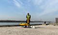
  • The entire project including calibration, mission planning, and processing can be accomplished by a single person
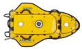
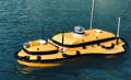
  • The Apache 4 is made of a durable yet lightweight mixture of carbon fiber and Kevlar fiber-glass weighing 7 kg allowing for easy transport
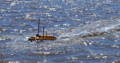
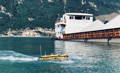
  • With no regulations for operating an USV, the Apache is quick and easy to use on any job
  • 4G connectivity allows RC control at all times in large bodies of water

  • 2.

    Safety

  • The Apache 4 comes equipped with an obstacle avoidance radar system for maximum security
  • 360 camera with live video feed keeps the USV safe in case of difficult weather conditions or loss of visibility
  • The Apache 4 is completely autonomous and operate safely from shore
  • AutoPlanner and HydroSurvey combine to allow the user to create an mission, survey the area, and view the results without being put in danger

  • 3.

    Echo Sounder and ADCP Synchronization

  • Single beam sounding data can be used to verify the accuracy of ADCP bottom tracking data
  • The beam sounding data is fed directly into the ADCP flow measurement software to compensate for the unavailability of ADCP data
  • Provides water depth profile data associated with the flow velocity profile measurements

CONTACT US

Want to get in touch with us? Just fill out the form below and we'll get back to you ASAP.

BACK TO TOP