[Webinar] ScoutDI: Revolutionizing Confined Space UTM Inspections. Register Now

Call Us: +1 866 300 9012

contact@measur.ca

Call Us: +1 866 300 9012

contact@measur.ca
SHOPPING CART

No Products in the Cart

TOTAL:
$0.00

Choosing the Right Tool For Hydrographic Surveys: Echosounder, Multibeam or Drone LiDAR

Underwater mapping plays a crucial role in various fields such as hydrography, oceanography, and marine engineering. Two commonly used tools for this purpose are bathymetric liDAR and echo sounders. While both of these technologies serve the same purpose of mapping underwater terrain, they differ in terms of their working principles, accuracy, efficiency, and cost-effectiveness. In this article, we will delve into the details of bathymetric lidar and echo sounders, compare them in different aspects, and discuss the factors to consider when choosing the right tool for underwater mapping.
Advancements in drones and bathymetric technologies have revolutionized underwater mapping. Among the notable solutions are the DJI Matrice 350 RTK with the EchoLogger ECT D052S, Yellow Scan Navigator, and the CHCNav Apache 3, 4 and 6. Each offers unique features catering to various needs in industries like environmental monitoring, infrastructure assessment, and underwater exploration.

Understanding Bathymetric LiDAR

Bathymetric LiDAR like the Yellow Scan Navigator utilizes laser technology to determine the distance between the sensor and the seafloor. It emits laser pulses which are then reflected back to the sensor. By measuring the time taken for the pulses to return, bathymetric lidar can calculate the water depth. This technology is often used in shallow waters and provides accurate and detailed data of the seafloor topography.

The Science Behind Bathymetric LiDAR

The working principle of bathymetric lidar  is based on the measurement of the time-of-flight of laser pulses. By emitting laser pulses towards the water surface and measuring the time it takes for them to return, the system can determine the water depth. This is achieved by using specialized algorithms that take into account factors such as the speed of light in water and the sensor's position. 

Bathymetric LiDAR operates by emitting strong, short laser pulses with a wavelength of 532 nm (green light) from a LiDAR device at a high frequency. As the light enters the water, it undergoes refraction, changing its angle, and is scattered and absorbed before reaching the water's bottom. If the water is transparent enough and the laser is strong, some of the light reflects off the bottom, with the bottom type influencing reflectivity. For instance, white sand reflects more light than dark mud, which absorbs it. The bathymetric LiDAR sensor detects the reflected light photons and converts them into digital signals, creating detailed waveforms for each pulse. By analyzing these waveforms, the moment the laser pulse hits the water surface and bottom can be determined, enabling the calculation of water depth. This information has various applications in underwater mapping and research.

Key Features of Bathymetric LiDAR

Bathymetric lidar systems are equipped with several key features that make them effective for underwater mapping. These include high-resolution sensors, advanced signal processing algorithms, and real-time data visualization capabilities. The high-resolution sensors ensure accurate measurement of the water depth, while the advanced algorithms enhance the quality of the collected data. The real-time visualization allows users to monitor the mapping process and make necessary adjustments if needed.

Advantages and Limitations of Bathymetric LiDAR

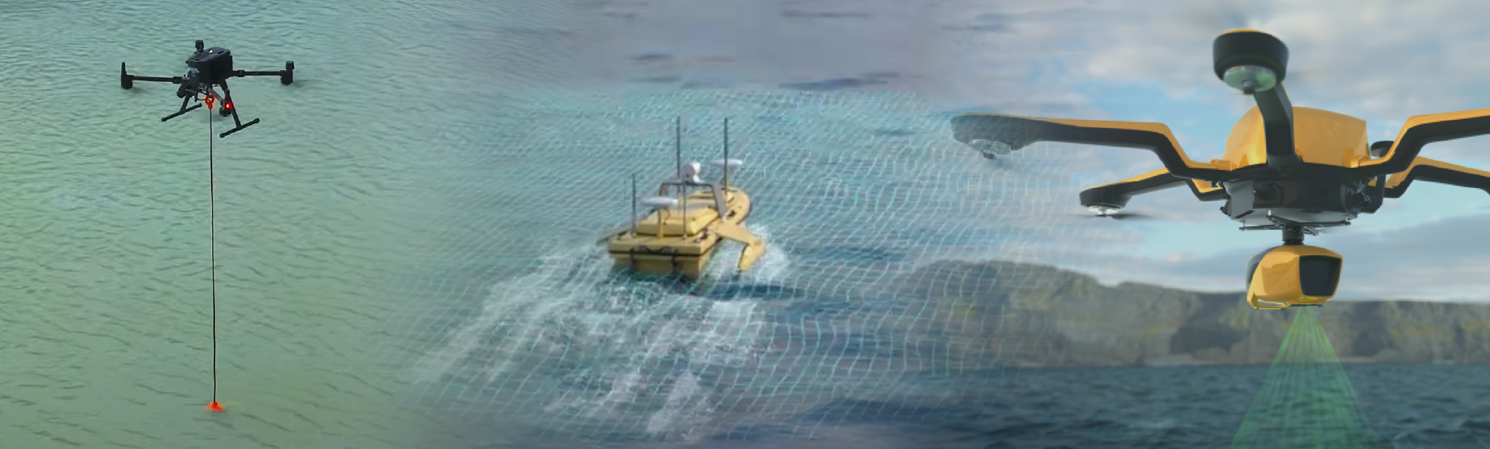
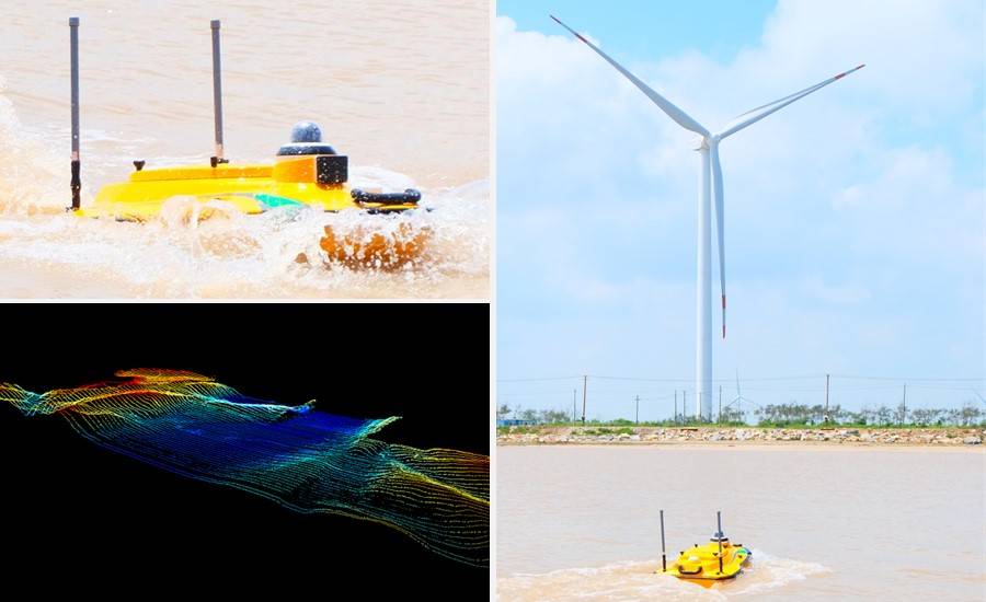
Bathymetric LiDAR offers several advantages for underwater mapping, including speed, reliability, accuracy, and safety, enabling detailed and precise mapping of nearshore waters, beaches, and coastal structures. Compared to traditional methods like sonar, it can provide more comprehensive maps of both water and land, reaching depths up to three times greater than visible water depth. The use of green light allows for deeper penetration into the water and reduces inaccuracies caused by suspended particles, making it a sustainable and safer option that eliminates the need for costly survey vessels or human entry into the water. However, challenges remain, as the effectiveness of bathymetric LiDAR can be affected by factors such as water transparency, turbidity, bottom reflection, and the strength of the laser pulse, necessitating tailored solutions for different projects.

Delving into Echo Sounders

Unlike bathymetric lidar, echo sounders use sonar technology to measure the water depth. They emit sound waves which travel through the water and bounce back when they encounter the seafloor or other underwater features. By measuring the time taken for the sound waves to return, echo sounders can calculate the water depth and create a profile of the seafloor.

The Working Principle of Echo Sounders

Echo sounders like the Apache 3 USV work on the principle of sound wave reflection. They emit sound waves, often in the form of a pulse, and measure the time it takes for the waves to reflect back. This time measurement is then used to determine the water depth. Echo sounders utilize a transducer that converts electrical signals into sound waves and vice versa. The transducer emits sound waves and receives the reflected echoes, enabling the calculation of the water depth.

Essential Characteristics of Echo Sounders

Modern echo sounders come with various features that enhance their performance and accuracy. Some of these features include multiple frequency options, beam forming capabilities, and data visualization tools. Multiple frequency options allow users to select the frequency that best suits the water conditions and target depth range. Beam forming capabilities improve the accuracy of the data by controlling the direction of the emitted sound waves. Data visualization tools enable real-time viewing of the seafloor profile, aiding in data interpretation and quality control.

Pros and Cons of Using Echo Sounders

Echo sounders  offer several advantages for underwater mapping. They are cost-effective compared to bathymetric lidar systems, making them suitable for budget-constrained projects. Echo sounders also have a greater depth penetration capability. However, echo sounders have limitations concerning the accuracy of the measured data, as they can be affected by factors like signal attenuation and reflection interference.

Comparing Bathymetric LiDAR and Echo Sounder

Accuracy Comparison

In terms of accuracy, bathymetric lidar generally provides higher resolution and accuracy compared to echo sounders. This is due to the direct measurement of the laser pulses in bathymetric lidar, whereas echo sounders depend on the quality of the sound waves and their reflections. However, it is important to note that the accuracy of both technologies can be affected by environmental factors and the quality of calibration and data processing techniques.

Efficiency in Different Water Conditions

When it comes to water conditions, echo sounders have an advantage in turbid or murky waters. Bathymetric lidar systems utilize laser pulses to measure depths underwater, which can be impeded by suspended particles or sediment in murky waters. As a result, bathymetric lidar may face challenges in such conditions, potentially leading to less accurate depth measurements. In contrast, echo sounders, which use sound waves to measure depths, are less affected by water clarity and can provide reliable depth measurements even in turbid or murky waters. Therefore, in environments with poor water clarity, echo sounders may have an advantage over bathymetric lidar systems. In clear waters, both technologies can perform efficiently, although echo sounders may have a slight advantage in deep waters.

Cost-effectiveness Analysis

Cost-effectiveness is an essential factor to consider when choosing an underwater mapping tool. Bathymetric lidar systems typically have high initial costs due to the sophisticated sensors and software required. However, they offer long-term cost advantages in terms of data accuracy and collection efficiency. Echo sounders, on the other hand, have lower initial costs but may require additional equipment or modifications for specific mapping requirements. The overall cost-effectiveness depends on the specific project requirements and budget constraints.

Considerations

Considerations for Shallow Waters

In shallow waters, bathymetric lidar is often the preferred choice due to its accuracy, high resolution, and ability to penetrate through turbidity. It provides detailed information of the seafloor, critical for applications such as coastal zone management, environmental monitoring, and habitat mapping. The availability of real-time visualization also enables immediate feedback and adjustments during the mapping process, ensuring accurate and efficient data collection.

Evaluating the Impact of Water Clarity

Water clarity can significantly affect the performance of both bathymetric lidar and echo sounders. In clear waters, both technologies can provide accurate depth measurements. However, in turbid or murky waters, bathymetric lidar tends to outperform echo sounders due to its ability to penetrate through the suspended particles or sediment. It is crucial to consider the clarity of the water and select the appropriate technology accordingly.

Choosing the Right Tool for Underwater Mapping

DJI Matrice 350 RTK with the EchoLogger ECT D052S

The DJI Matrice 350 RTK and EchoLogger ECT D052S create a formidable partnership for comprehensive aerial and underwater data acquisition. This combination is particularly potent for projects that demand a seamless transition between aerial and underwater surveys. Whether mapping coastlines, conducting environmental assessments, or executing precision inspections, the integration of these technologies ensures a holistic approach to data collection.

The collaborative use of the Matrice 350 RTK and EchoLogger ECT D052S expands the horizons of bathymetric surveys, providing a comprehensive solution for projects that demand excellence in both aerial and underwater data collection.
Key Features
• O3 Enterprise Transmission System for advanced live feeds.
• IP55 Protection Rating for harsh environments.
• Enhanced flight performance with night-vision FPV camera and 6-Directional Sensing & Positioning.
• Dual Battery System for seamless hot-swapping.
Sale Off
DJI Matrice 350 RTK
$10,209.00
Offered by SPH Engineering, the EchoLogger ECT D052S is a high-quality dual-frequency echo sounder designed for underwater mapping. With a weight of 460 g and compatibility with the DJI Matrice 350 RTK, it's a reliable tool for hydrographic surveys.
Key Features
• Dual-frequency echo sounder with tilt and temperature sensors.
• Advanced water depth analysis algorithm for accurate results.
• Type: Dual-frequency
• Acoustic Frequency, kHz: 50/200
• Measurement range: 1.0 - 200m (50 kHz) | 0.5 - 200m (200 kHz)

This solution is specifically crafted for underwater mapping and exploration, making it an ideal choice for hydrographic surveys. Its compatibility with DJI M350 RTK ensures seamless integration into existing workflows.
Sale Off
EchoLogger ECT D052S Echo Sounder
$0.00

YellowScan Navigator

The YellowScan Navigator, with an AGL Altitude of 100 m and a system precision and accuracy of 3 cm, is a bathymetric LiDAR system designed for high-accuracy topographic mapping of shallow water.
Key Features
• Integrated INS and embedded camera for precise data collection.
• High-performance LiDAR optimized for bathymetric survey applications.
• Multi-platform compatibility for versatile use.
Tailored for underwater topography mapping, the YellowScan Navigator excels in collecting detailed data in diverse environments, including rivers, lakes, and oceans.
Sale Off
YellowScan Navigator
$0.00

Apache 3 Pro

The Apache 3, with over 2 hours of endurance and a maximum speed of 5 meters per second, offers a portable and efficient solution for shallow water bathymetric surveys. Its single beam echo sounder, D230, ensures high accuracy.
Key Features
• Tangle-Proof Motors for navigating difficult weather conditions.
• One-Man Operation for streamlined fieldwork.
• 4G connectivity for RC control in large bodies of water.

Suited for quick and easy one-man operations in shallow water bodies, the Apache 3 is a go-to solution for bathymetric surveys in lakes, inland rivers, and coastal areas.
Sale Off
Apache 3
$1.00

Apache 6

The apache 6 is a lightweight and high-performance unmanned surface vessel designed for easy deployment in various water conditions. It features a triple-hulled design for stability, optimized for NORBIT multibeam echosounders, and optional terrestrial mapping laser sensors. With its versatility, it can be used for offshore, coastal, and inland water surveys, as well as for tasks like underwater object positioning and wreck rescue. Powered by a dual propeller system, it can maintain a stable cruising speed and offers both automatic and manual control modes. The optional equipment includes LIDAR scanners, and fish finder transducers, providing comprehensive data for marine surveys and research.
Key Features
  • Over Hours of Battery Endurance
  • Max Speed of  Meters Per Second
  • Maximum Payload of 60 Kilograms
  • Compatible With ADCP Payloads from Industry Leaders
Sale Off
CHCNAV Apache 6 USV Marine Drone
$0.00
Ultimately, the choice between these bathymetric lidar and echo sounders depends on various factors such as the project requirements, water conditions, budget constraints, and data accuracy needs. These technologies offer unique capabilities and advantages for underwater mapping. Evaluating these features and factors, and selecting the most suitable tool will ensure successful and effective underwater mapping projects, contributing to the advancement of hydrography, oceanography, and marine engineering.

RELATED POSTS

[WEBINAR REWIND] How Suncor Utilizes Drones to Manage one of Canada’s Largest Drone Programs with Measur and Flight Insight
In the ever-evolving landscape of technological innovation, industries are constantly seeking new ways to enhance efficiency, safety, and environmental responsibility....
The Ultimate Guide to Ground Penetrating Radar (GPR)
Ground Penetrating Radar (GPR) is a geophysical technique that uses electromagnetic waves to create subsurface images and detect objects buried...
The Importance of Indoor Drone Inspections with Scout 137
Traditional methods of confined space inspections often involve sending human inspectors into hazardous environments. However, with the advancement of technology,...

Get in touch

Give us a call or drop by anytime, we will answer all enquiries within 24 hours on business days. We will be happy to answer your questions.

Contact Information

We would love to hear from you! Our team is always here to help.

  • +1 866 300 9012

  • contact@measur.ca

  • Vancouver, British Columbia

    Calgary, Alberta

    Mississauga, Ontario

    Montreal, Quebec

Name*:

Phone*:

Email*:

Message:

BACK TO TOP