No Products in the Cart
When it comes to Drones for survey and mapping, many options are available for a variety of industries such as agriculture, mining, construction and more, to efficiently create detailed maps and 3D models. Choosing the right solution might be challenging as there are a variety of options on the market that all have an array of different features.
In this blog, we compare the best three drones and payloads developed by DJI for surveying and mapping professionals. The solutions are listed in descending order.
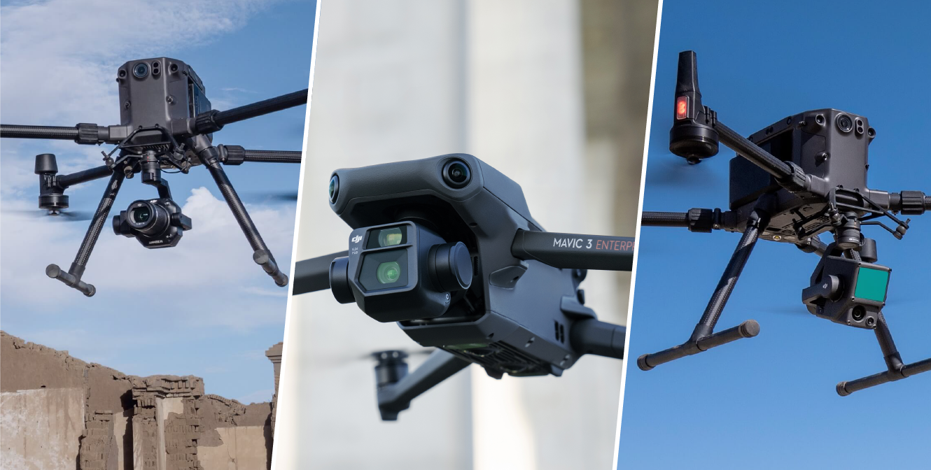
The DJI Zenmuse P1 combined with M300 RTK is one of the most powerful combinations on the market for effective reality capture and survey projects that require the most accurate results. The P1 includes a 45 MP full-frame, low-noise high-sensitivity sensor that can take a photo every 0.7 s during the flight, and covers 3 km2 in a single flight.
While it is hard to beat the Mavic 3 Enterprise in terms of portability, the Zenmuse P1 has gained its position due to its camera resolution and pixel size. Generally, a high-resolution image leads to a better quality map or highly detailed model and larger pixels can ensure a better image's dynamic range and quality under low light conditions. This allows drone pilots more extended operational time in difficult environments and conditions.
2) DJI Mavic 3 Enterprise with RTK module
The DJI Mavic 3 Enterprise with RTK module is ideal for surveying professionals who desire a portable, easy-to deploy, survey-grade solution. The M3E features a 20 MP ultra-wide-angle camera, along with a 56x hybrid zoom camera. Moreover, the Mavic 3 Enterprise's 0.7s mechanical shutter can significantly improve your drone models eliminating image blur commonly associated with rolling shutters. It offers up to 45-minute flight time with 32 km of range and 15 m/s top speed. The RTK module is directly integrated with the Mavic 3 Enterprise and the drone can receive corrections from several sources including the DJI D-RTK2 Base Station, third-party GNSS receivers such as the Stonex GNSS or Emlid Reach RS2+, Ntrip, and more. For more information on this, read through our blog post titled "DJI MAVIC 3 ENTERPRISE: FIRST-TIME SURVEY SETUP GUIDE".

3) Matrice M300 RTK + Zenmuse L1
Lastly, the Matrice M300 RTK with Zenmuse L1 has been the leading choice for surveyors who prefer an affordable, airborne LiDAR technology. This payload also allows the colorization of the LiDAR data and basic mapping capabilities for an orthophoto.. The Zenmuse L1 integrates a Livox LiDAR module, a high-accuracy IMU, and a camera with a 1-inch CMOS on a 3-axis stabilized gimbal. It offers real-time 3D data throughout the day, efficiently capturing the details of complex structures and delivering highly accurate reconstructed models.

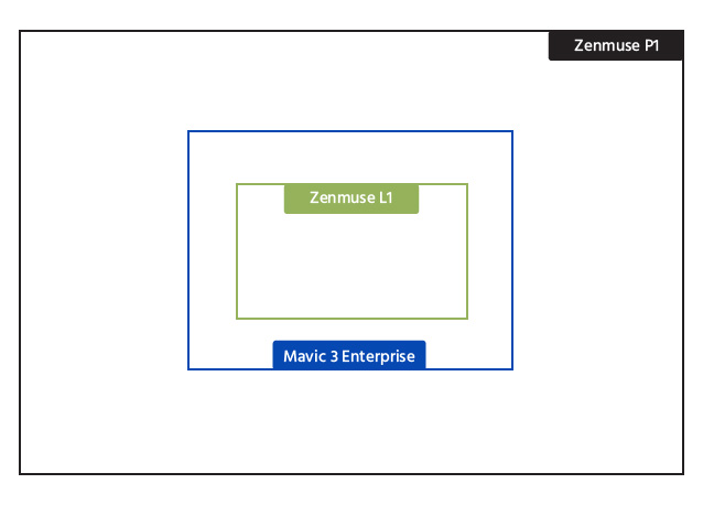
Visual Comparison: Camera Sensor Size (black = P1, blue = Mavic 3 E, green = L1)
In this section, you can easily refer to and quickly obtain important information that can further help you choose the right technology. These specifications are based on the published specifications by DJI.
Survey-grade Drone Solutions
Mavic 3 Enterprise with RTK Module ( Wide Camera)
Matrice M300 RTK + Zenmuse P1
Matrice M300 RTK + Zenmuse L1
Survey Grade
Yes
Yes
Yes
RTK/PPK Support
Yes
Yes
Yes
GSD (cm)
H(m)/36.5
24mm: H(m)/5535mm: H(m)/8050mm: H(m)/120
H(m)/36.5
Sensor Size
4/3"5280 × 3956 (4:3)
Full-frame(35.9×24mm)8192 × 5460 (3:2)
1"5472 × 3648 (3:2)
Still Resolution
20MP
45 MP
20 MP
Pixel Size
3.3μm
4.4μm
2.4μm
Lens Option
12mm/24mmEquivalent FOV 84.0°
DL 24mm; FOV 84.0°DL 35mm; FOV 63.5°DL 50mm; FOV 46.8°
8.8mm/24mmEquivalentFOV 84.0°
Mechanical Shutter
Yes(1/2000-8s)
Yes(1/2000-1s)
Yes(1/2000-8s)
Minimum Photo Interval
0.7s
0.7s
2.5s
Flight Time
Up to 42 mins (WithRTK Module)
Up to 44mins
Up to 42 mins
Memory Requirement
microSDUHS-I Speed Grade3 rating or aboveMax Capacity:512GB
SDUHS-I rating or aboveMax Capacity: 512GB
microSDUHS-I Speed Grade 3rating or aboveMax Capacity: 256GB
Maximum WindResistance
Up to 26mph
Up to 33mph
Up to 33mph
Smart Oblique Support
(Support Planned)
Yes
No
Real-time Terrain-follow
(Support Planned)
No
No
SDK & 3rd Party app Support
Yes
Yes
Want to learn more about the best unmanned options for surveying and mapping applications?
Book a free consultation, and one of our drone specialists will be happy to assist you.