No Products in the Cart
[Webinar] ScoutDI: Revolutionizing Confined Space UTM Inspections. Register Now
Call Us: +1 866 300 9012
contact@measur.caCall Us: +1 866 300 9012
contact@measur.caDJI Terra is back with its latest updates, V3.7 and V3.8, packed with cutting-edge features that offer high efficiency for your projects. In this blog post, we'll walk you through the most exciting enhancements that DJI Terra brings to the table.
In geospatial data collection, ground control points play a crucial role in ensuring the accuracy and reliability of results. Previously, surveyors had to painstakingly mark corresponding ground survey markers in multiple photos manually. But with DJI Terra's V3.7 update, that's now a thing of the past.
This release introduces the revolutionary Automatic Mark Identification feature. Surveyors only need to manually mark one photo for the control point/checkpoint, and the software will do the rest, automatically identifying the same control point/checkpoint in other photos.

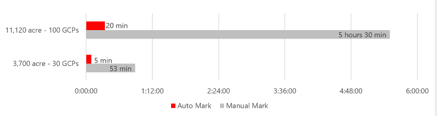
Data Comparison Results:
For example, in a 45 km² oblique photogrammetry project with 100 ground control points, manual marking typically took around 5.5 hours. After using the Automatic Mark Identification feature, this process was streamlined to just 20 minutes, saving over 5 hours of time.
For a 15 km² orthophoto project with 30 ground control points, manual marking previously took about 53 minutes. After adopting the automatic marking feature, the time was reduced to just 5 minutes, saving nearly 50 minutes of work.
How to access to this feature: Create a visible light mission > Add photos > aerotriangulation settings > Advanced settings > GCP management > Automatic Mark Identification
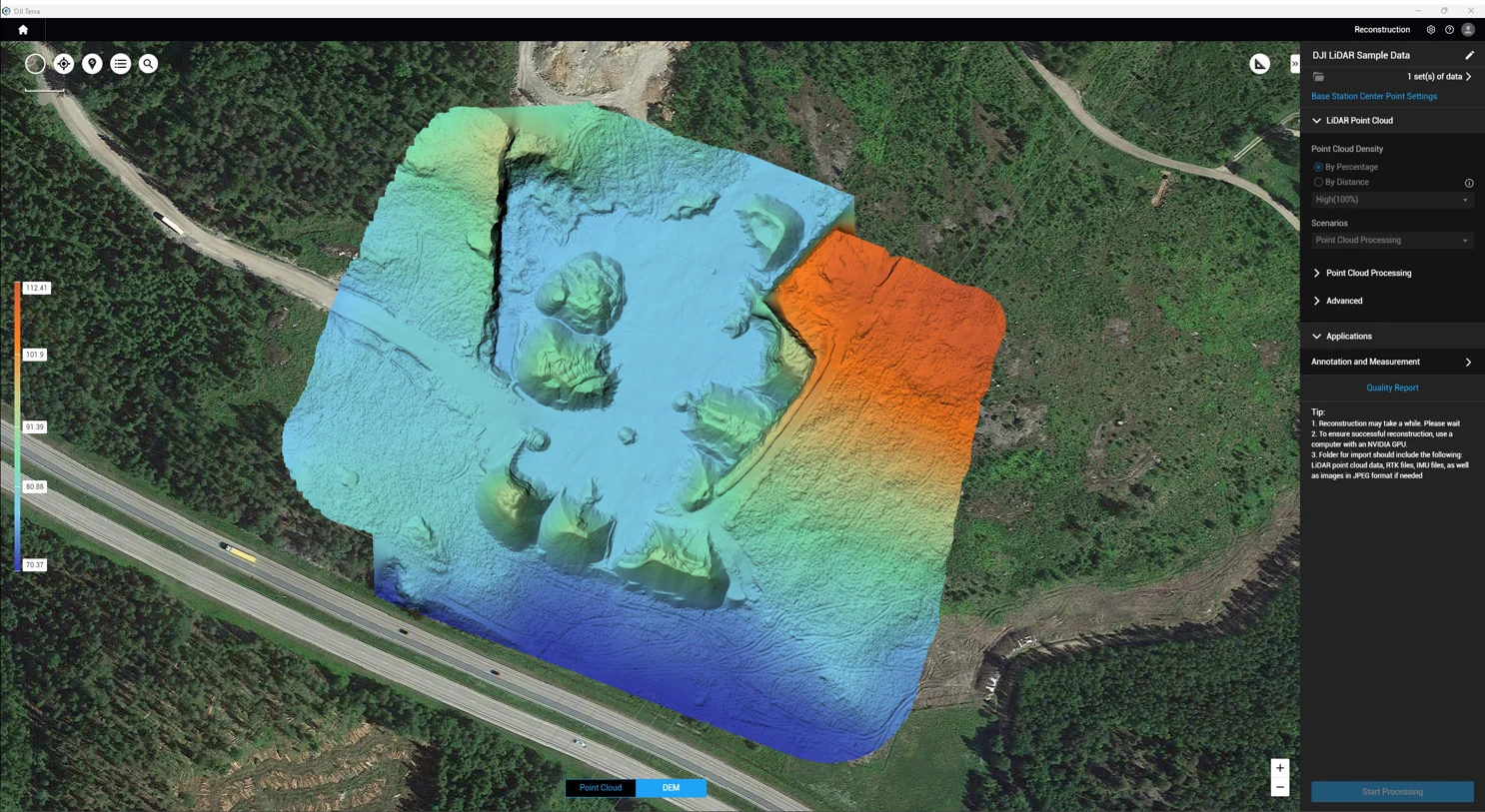
Classifying ground points in the point cloud is essential when using L1 for data collection and DEM creation. DJI Terra V3.7.0 simplifies this process by introducing an in-built classification feature, eliminating the need for third-party software.
How to access this feature: Create a Lidar point cloud mission > Add Lidar data > Point Cloud Processing settings > Check the Ground Point Type box
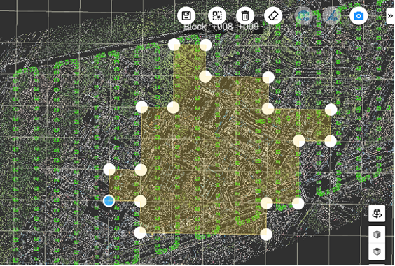
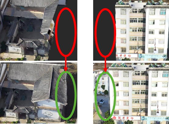
In large-scale 3D projects, dividing the region into multiple blocks for reconstruction and later merging can be a daunting task. But not with DJI Terra V3.7.0. This version now supports automatic alignment of reconstruction blocks based on the region of interest boundaries. This ensures precise data stitching and adherence to industry standards.

Only rebuilding the edge blocks partially may cause missing data.
V3.7.0 version can automatically align blocks along edges to avoid data missing.
When you utilize the 'Auto Align Blocks' feature, it ensures that all relevant blocks within the designated area are accurately reconstructed, guaranteeing seamless data integration.
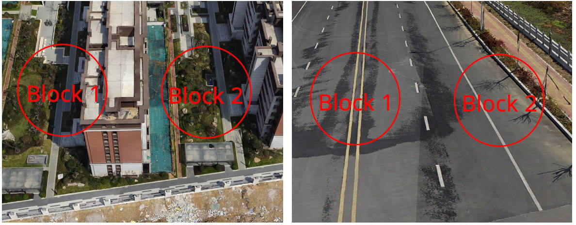
The architectural elements and road surfaces are clearly visible, and the stitching outcomes are flawless, displaying no noticeable gaps.
Prior to utilizing this feature, it's crucial to verify the following conditions: ensure that block parameters, such as the coordinate origin and coordinate system, remain consistent; confirm the accuracy of aerotriangulation results; check for the presence of control point constraints at block overlaps between different reconstruction blocks, and ensure that there is sufficient overlap. Failure to meet these conditions could lead to uneven stitching in the final model.
How to access this feature: Create a Visible Light Task > Add Photo > 3D Model > Advanced Settings > Area of Interest/Block > Import KML Range (optional) > Edit Area of Interest.
Displaying 3D models online can be resource-intensive, especially for complex, highly detailed models. DJI Terra V3.7.0 introduces a "Reduce Model Size" feature, significantly reducing the number of triangles in the model. This improves the smoothness and loading speed of online model reviews.
When you enable the model size reduction feature in DJI Terra, the software aims to preserve model accuracy but may lose some fine details. For tasks requiring high detail fidelity, it's recommended to either turn off the size reduction feature or set the size reduction parameter to over 80%. Using a parameter below 20% could cause texture map misalignment in flat areas.


When using 50% resolution, the model remains virtually unchanged.
When using 10% resolution, the model loses many details.
How to access this feature: Create a Visible Light mission > Add Photo > 3D Model > Advanced Settings > Reduce the model to XX%
DJI Terra V3.7.0 doesn't just stop at geospatial data processing; it enhances the quality reporting experience. The quality reports are now more comprehensive and aesthetically pleasing, including critical parameters such as GCP, camera distortion reprojection maps, and photo POS residual lists.

Digital Elevation Models (DEMs) are a cornerstone of geospatial data representation. DJI Terra V3.8.0 takes it a step further by introducing an improved DEM generation algorithm that supports the generation of DEM data in Tiff format based on ground point cloud data.
DEM Generation
| Scale | GSD |
|---|---|
| 1:500 | 50cm |
| 1:1000 | 100cm |
| 1:2000 | 200cm |
This version also features an upgraded Optimize Point Cloud Accuracy algorithm, ensuring higher-precision point cloud results.
GCP Landmark Shape in Point Cloud

With this update, circular features appear more rounded and closer to their real shapes.

The use of the Optimize Point Cloud Accuracy significantly reduces stratification phenomena.
With this update, circular features appear more rounded and closer to their real shapes.
Additionally, the quality report for point clouds has been further improved in V3.8.0. It offers better visualization and more intuitive data representation.
These updates in DJI Terra V3.8.0 are a testament to our commitment to delivering the most advanced geospatial data processing tools available.
DJI Terra V3.7 and V3.8 are transformative updates that will take your geospatial data processing to new heights. With features like Automatic Ground Control Point Identification, L1 Data Ground Point Cloud Classification, Automatic 3D Block Alignment, Reduce Model Size, and enhanced Quality Reports, you can expect higher accuracy and efficiency in your projects.