No Products in the Cart
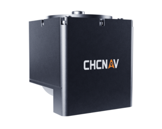
The HQ-400 Multibeam Sonar System offers integrated functionality for seamless underwater terrain measurement.
Integrated Design: Combines small multi-beam sonar, temperature sensor, attitude, positioning, compass, and other core sensors into a compact and integrated system.
Calibration-Free Operation: With no installation and calibration required, the HQ-400 Multibeam Sonar System offers convenience and ease of use, especially on small unmanned carrier platforms such as the Apache 3 and Apache 6.
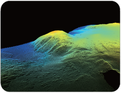
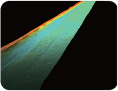
The CMS Multibeam Acquisition Software provides a comprehensive solution for underwater terrain measurement. Its compact, lightweight design coupled with advanced features makes it an ideal choice for various applications, from river profiling to hydrographic surveys.


Simple and Calibration-Free: Enjoy hassle-free operation with no presetting required. The software is designed for simplicity and efficiency in data acquisition.

Ultra-High Stability: Equipped with a high-performance SOC system chip, the CMS Multibeam Acquisition Software ensures ultra-high stability, even in challenging environments.

CMS Multibeam Measurement Software: The CMS Multibeam Measurement Software provides powerful tools for data acquisition and visualization, enhancing efficiency and accuracy in survey tasks.
Comprehensive Compatibility: Compatible with various positioning, attitude instruments, compasses, and multi-beam equipment, ensuring seamless integration into existing setups.
Intuitive Operation: Features a user-friendly interface with advanced planning and line layout functions, enabling surveyors and helmsmen to complete tasks efficiently.
CMS Multibeam Post-Processing Software: Complete your underwater survey workflow with the CMS Multibeam Post-Processing Software, offering advanced data processing capabilities.
One-Stop Solution: Seamlessly integrates with the CMS Multibeam Measurement Software to form a comprehensive solution for data acquisition and processing.
Highly Efficient Processing: Utilizes hardware encryption locks and advanced algorithms for fast and accurate data processing, eliminating system errors and delivering high-quality results.

Applications: The CMS Multibeam Acquisition System is suitable for a wide range of applications, including:
Topographic Survey: Accurately measure underwater terrain for topographic mapping and analysis.
Capacity Calculation: Determine capacity and volume measurements for reservoirs, channels, and other water bodies.

Hydrographic Survey: Conduct detailed hydrographic surveys for navigation, dredging, and environmental monitoring.
River Profile Survey: Study river profiles to understand water flow, erosion patterns, and sediment transport.

HQ-400 Specifications
Specifications (Version 24.01):
Sonar:
Feature:
Physical: