No Products in the Cart
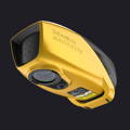
Precision: 3 cm (1.2")
Accuracy: 3 cm (1.2")
Typ. flight speed: 5 m/s
Max. AGL altitude: 100 m
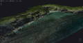
Laser range: Up to 120 m
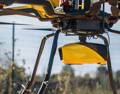
Laser scanner: YellowScan development
GNSS-Inertial solution: SBG Quanta Micro
Echoes per shot: Up to 10
Shots per second: Up to 20 000
Scanning frequency: Up to 50 Hz
Weight: 3.7 kg (8.2 lbs) battery excl.
Size: L 350 x W 160 x H 190 mm
Autonomy: 45 min. typ.
Power consumption: 120 W
Operating temperature: 0° to +40 °C
Nominal ocular hazard distance: 25 m
Laser class: Class 3B