Call Us: +1 866 300 9012

contact@measur.ca
SHOPPING CART

No Products in the Cart

TOTAL:
$0.00

What Makes the YellowScan Voyager a Unique Drone-Based LiDAR System

The YellowScan Voyager is not just another LiDAR system; it's a cutting-edge solution that stands out in the industry for several reasons, making it particularly valuable for professionals who require the highest precision (less than 1 cm accuracy ) and efficiency in their tasks. Here’s what sets the Voyager apart from a technical standpoint and how it enhances professional applications.

1. Exceptional Point Density and Data Quality

One of the most remarkable features of the YellowScan Voyager is its 100° laser scanner, which can achieve a data acquisition rate of up to 2400 kHz. This translates to an extraordinary point density, capturing more data points per second than most other systems on the market. For professionals, this means the ability to create highly detailed and accurate 3D models of the terrain, infrastructure, or vegetation. From dense forests to intricate urban environments and expansive industrial sites, the Voyager ensures that no detail is overlooked.

2. Advanced Multi-Sensor Integration

The Voyager is designed with versatility in mind, allowing it to be equipped with an RGB camera module. This integration is a game-changer for professionals who need to collect both LiDAR data and high-resolution imagery simultaneously. The ability to synchronize these datasets means that you can overlay detailed photographic data onto the precise topographical information captured by the LiDAR, providing a richer, more comprehensive dataset for analysis and decision-making.

3. Cutting-Edge Technology from Industry Leaders

Under the hood, the YellowScan Voyager features components from industry leaders such as Applanix and Riegl. These names are synonymous with precision and reliability in the geospatial industry. The Applanix GNSS-Inertial system ensures that the Voyager maintains its accuracy even in challenging environments, such as areas with limited satellite visibility or difficult terrain. Meanwhile, Riegl’s laser scanning technology is renowned for its precision and robustness, ensuring that the Voyager delivers consistent and reliable data.

For professionals, this means confidence in the quality of the data being collected, which is crucial for applications where even the smallest error can have significant consequences, such as in surveying, construction, or environmental monitoring.

4. Precision and Accuracy Tailored for Professional Needs

The Voyager’s specifications speak directly to the needs of professionals. With a system precision of 0.5 cm (0.2 inches) and system accuracy of 1 cm (0.4 inches), it’s clear that the Voyager is built to meet the demands of tasks that require the highest level of accuracy. Whether you're working on high-stakes projects like infrastructure development, where precise measurements are critical, or environmental studies that require detailed terrain modelling, the Voyager’s accuracy ensures that your data is reliable and actionable.

5. Versatility Across Multiple Platforms

The YellowScan Voyager’s adaptability across various platforms is another key factor that makes it unique. Whether you’re deploying it on a multirotor drone, or a light manned aircraft, the Voyager’s performance remains consistent and reliable. This versatility is particularly beneficial for professionals who work in diverse environments or on a wide range of projects. For example, a surveyor might use the Voyager on a drone for small-scale, high-detail mapping, and then mount it on a light aircraft for large-scale topographic surveys. This flexibility means that one investment in the Voyager can serve multiple purposes, maximizing its value.

6. High Altitude Capability

The Voyager’s ability to operate at altitudes of up to 440 meters (1444 feet) AGL (Above Ground Level) makes it suitable for a variety of mission profiles, from low-altitude detailed surveys to high-altitude wide-area scans. This capability is especially important for professionals working in industries such as forestry, where different altitudes are required to capture data at various scales, or in large infrastructure projects where both detailed site surveys and broader regional assessments are necessary.

7. Professional-Grade Software Integration

To complement its hardware capabilities, the YellowScan Voyager is supported by professional-grade software that enhances productivity and simplifies data processing. The software solutions offered by YellowScan are designed to integrate seamlessly with the Voyager’s data, providing tools for terrain modelling, volumetric analysis, and more. This allows professionals to streamline their workflows, reduce the time spent on data processing, and increase the accuracy of their final deliverables.

8. User-Centric Design with Professional Support

YellowScan understands the needs of professional users, which is why the Voyager is not only equipped with top-of-the-line technology but also backed by comprehensive support. From detailed documentation and a robust knowledge base to personalized customer support and optional add-ons, the Voyager is designed to meet the specific needs of its users. This ensures that professionals can focus on their work with the confidence that they have the support and tools they need to succeed.

Application to Professional Tasks

The 
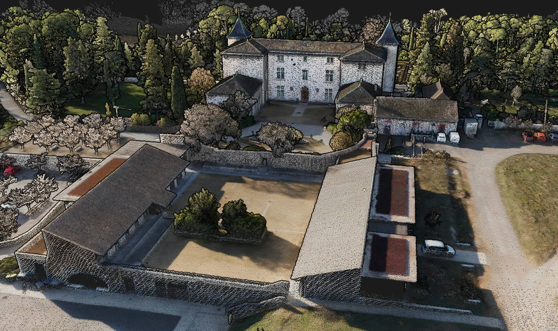
YellowScan Voyager boasts technical features that offer significant advantages across a range of professional applications. In surveying and mapping, its high point density and precision are key for producing accurate topographic maps, land surveys, and construction site plans. In environmental monitoring, the Voyager excels at capturing detailed terrain and vegetation data, making it ideal for tracking ecosystem changes, assessing environmental shifts, and managing natural resources. For infrastructure inspection, professionals benefit from its high-resolution data, which enables precise measurements and detailed assessments, significantly reducing the risk of errors. In forestry management, the Voyager’s ability to operate at varying altitudes and capture both LiDAR and photographic data makes it a valuable tool for forest inventory, canopy analysis, and biomass estimation.

In conclusion, the YellowScan Voyager is a highly specialized tool designed to meet the rigorous demands of professional tasks. Its advanced technical features, combined with its versatility and reliability, make it an indispensable asset for professionals in geospatial, environmental, and infrastructure sectors. By leveraging the Voyager’s capabilities, users can complete more mission profiles with confidence and deliver superior results to their clients.

RELATED POSTS

Top Features of the DJI Matrice 30T
The DJI Matrice 30T is engineered to excel in a variety of demanding environments, offering a suite of advanced features...
How to Select the Best Drone-Based Ground Penetrating Radar
Ground Penetrating Radar (GPR) technology has transformed how we explore and understand what's beneath the surface, making it an essential...
What Makes the YellowScan Voyager a Unique Drone-Based LiDAR System
The YellowScan Voyager is not just another LiDAR system; it's a cutting-edge solution that stands out in the industry for...

Get in touch

Give us a call or drop by anytime, we will answer all enquiries within 24 hours on business days. We will be happy to answer your questions.

Contact Information

We would love to hear from you! Our team is always here to help.

  • +1 866 300 9012

  • contact@measur.ca

  • Vancouver, British Columbia

    Calgary, Alberta

    Mississauga, Ontario

    Montreal, Quebec

Name*:

Phone*:

Email*:

Message:

BACK TO TOP